National Energy Grid
|
 |
|
Full Size Map National Electricity Transmission Grid of Haiti (54 kb) |
GRID SUMMARY
Hispaniola (Haiti + Dominican Republic)
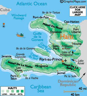
The island of Hispaniola is the second largest island in the Caribbean, at 29,273 sq miles, (75,843 sq km). Haiti occupies about 1/3 of the island, while the Dominican Republic controls the balance of land.
Columbus claimed Hispaniola in 1492, declaring it ( Isla Espanola, ) "the most beautiful island in the world." It later became the major launching base for the Spanish conquest of the Caribbean, as well as the American mainland.
Subsequently, disease and slavery were introduced by the Spanish conquistadors, and the indigenous Arawak peoples were destroyed.
In the 17th Century, with the Spanish in control, the French established a colony on the island. The Spanish later ceded the western third of Hispaniola in 1697, which in 1804 became known as Haiti.
The remainder of the island, then known as Santo Domingo, declared its independence in 1821, however, it was immediately occupied by Haiti. It finally gained total independence in 1844, and became the Dominican Republic.
ENERGY SUMMARY : Haiti
Map
of Haitian Electricity Grid |
National Energy Grid Index
GENI Home Page | Contact
GENI | Subscribe
to GENI Newsletter | Pledge
| Comments
| GENI Forum
Email this page to a friend
If you speak another language fluently and you liked this page, make
a contribution by translating
it! For additional translations check out FreeTranslation.com
(Voor vertaling van Engels tot Nederlands)
(For oversettelse fra Engelsk til Norsk)
(Для дополнительных
переводов проверяют
FreeTranslation.com )

