 Map")
|
|||||||
|
GENI offers a money-back guarantee on all products we sell. |
|||||||
Our Spaceship Earth - Satellite Self Portrait Dymaxion Map |
|||||||
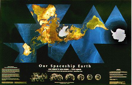
Fondly called Our Spaceship Earth, this map combines the latest in natural color satellite photograph technology with the accuracy of the Fuller Projection to create a truly stunning, cloud-free image of our world. The Satellite Self-Portrait Dymaxion Map shows a remarkable cloud-free view of Earth was produced by mosaicking hundreds of individual satellite images acquired from the NOAA (US National Oceanic and Atmospheric Administration) series of weather satellites which orbit the earth at an altitude of 520 miles (820 km). Once the base satellite mosaic had been completed, the land areas were enhanced with shaded-relief imagery bringing the Earth's topography to life. For the ocean areas, WorldSat incorporated ocean floor relief data enhanced with SST (Sea Surface Temperature) data, which revealed major ocean currents across the Earth. Richly colored blues, greens and ambers glow against a deep, matte black background. Sunlight is fixed at 45 degrees over the horizon in a north north-east orientation, creating a uniform shadow that clarifies relief for an excellent delineation of the mountains, plains and ocean floor features. This fabulous map is printed on 36" x 24" (92cm x 61cm) extra heavy-gauge high-gloss paper. Scale: approximately 1:43,520,000 (at the Equator). 1" = 686 miles, 1cm = 435 km. Digital Image Processing by Robert Gray and Jim Knighton, on a SGI workstation. |
|||||||
|
Price: $20.00 | Add to Cart |
|||||||
|
|||||||
|
GENI offers a money-back guarantee on all products we sell.
If you speak another language fluently and you liked this page, make
a contribution by translating
it! For additional translations check out FreeTranslation.com
(Voor vertaling van Engels tot Nederlands)
(For oversettelse fra Engelsk til Norsk) |
|||||||
|


|
|