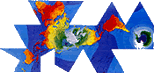
The Fuller (Dymaxion) Projection
Air-Ocean World
Unique Features of The Fuller Projection
- A map of the Earth which presents geographic information
in a single, comprehensive picture without breaks
in any of the continental contours, or any visible
distortion of the relative shapes or sizes of the
land masses.
- A world
projection with negligible distortion which can
accurately display at a glance global information
such as human migration patterns and the distribution
of natural resources.

A New Perception of Earth
World maps are symbolic tools which help to shape
our perception of Earth. Every world map projection
must make certain compromises as information is transferred
from a spherical globe to a flat surface. With this
in mind, as early as 1927 Buckminster Fuller, an educator,
engineer, architect, author, cartographer and futurist,
set out to develop the world's most accurate 2-dimensional
world map.
He wanted to provide a view of the whole Earth at
once which would have the ability to reveal major
trends in world affairs and show the shortest air
routes between land masses. Fuller predicted even
then that global travel would shift from the sea to
the sky and anticipated the emergence of what he termed
'a OneTown Air-Ocean World.'
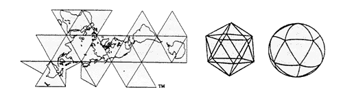
Designing for Accuracy
Using the some mathematical principles on which his
world famous geodesic domes were to be based, Fuller
carefully designed a way to display the world all
at once, with the least amount of visual distortion.
Throughout the next 26 years he refined his world
projection through many successive versions in order
to reach the highest level of accuracy.
In 1954 Fuller called his final icosahedral projection
the 'Dymaxion Air-Ocean World.' (The term 'Dymaxion'
was coined in the 1930's from Fuller's most commonly
used words: dynamic, maximum and tension.)
In 1980, an even more elegant and accurate Dymaxion
Map was developed by Fuller associates Rob Grip and
Christopher Kitrick, by using computer-generated algorithms
for latitude and longitude information. Now a brand
new edition of Fuller's remarkable map, 'The
Fuller Projection' has been designed and updated
by the Buckminster Fuller Institute using the distinguished
cartographic services of R.R. Donnelley & Sons.
A Tool for Global Responsibility
With our increasing global awareness, a world map
is needed which enables us to highlight the relationships
among all nations and cultures of the world rather
than one which emphasizes artificial boundaries between
them. Environmental concerns are becoming a central
focus of our international agenda. Therefore, we must
learn to see what unites us rather than what separates
us, and to chart global resources, population and
distribution patterns which characterize the complex
trends and critical needs of the world today.
In Fuller's own words, 'the Dymaxion Map reveals
a One-World Island in a One-World Ocean' which helps
us to view the world as one interdependent system
of relationships.
Dymaxion = Dynamic + Maximum
+ Tension = 'Doing More With Less'
The word DYMAXION and Fuller Projection Map designs are trademarks of the Buckminster Fuller Institute
Ś ®1938,1967 & 1992. All rights reserved.
The Fuller
Projection — Frequently Asked Questions
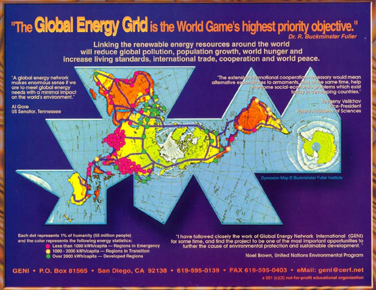
View Global Energy Grid (102 K)

|