|

Library >>
Renewable Energy Resource
Maps >> North America
>> Wind
Wind Energy Potential in NORTH AMERICA
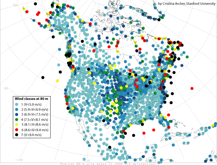
Map of mean 80-m wind speeds for year 2000

Wind speeds are calculated at 80 m, the hub height
of modern, 77-m diameter, 1500 kW turbines. Since
relatively few observations are available at 80
m, the Least Square extrapolation technique is utilized
and revised here to obtain estimates of wind speeds
at 80 m given observed wind speeds at 10 m (widely
available) and a network of sounding stations.
Tower data from the Kennedy Space Center (Florida)
were used to validate the results. Globally, ~13%
of all reporting stations experience annual mean
wind speeds ≥ 6.9 m/s at 80 m (i.e., wind
power class 3 or greater) and can therefore be considered
suitable for low-cost wind power generation. This
estimate is believed to be conservative.
Of all continents, North America has the largest
number of stations in class 3 (453).
http://www.stanford.edu/group/efmh/winds/global_winds.html
Availability of standardized evaluations
of the wind energy potential

Wind energy potential can not easily be shown in
simple overwiew maps. The map indicates the countries
for which wind energy evaluations are available.
These have been carried out by means of a standardized
method developped by the danish Risø Laboratory.
http://www.energie-atlas.ch/wi-100.htm
Countries
Canada
| Greenland | United
States of America
Related GENI Resources
Links
|
Email
this page to a friend
Updated: 2016/06/30
If you speak another language fluently and you liked this page, make
a contribution by translating
it! For additional translations check out FreeTranslation.com
(Voor vertaling van Engels tot Nederlands)
(For oversettelse fra Engelsk til Norsk)
(Для дополнительных
переводов проверяют
FreeTranslation.com )


